
Full Breakdown
Historic Mason-Dixon Survey Map Set for Auction
By Drooid · · How we work
In this breakdown
01
Auction Details
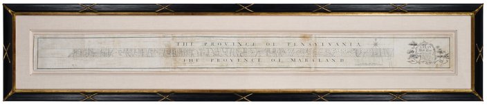
The original hand-drawn survey of the Mason-Dixon Line will be offered in a livestreamed auction on Thursday, October 29, by Brisk Auctions in Asheville, North Carolina. The seller remains anonymous. Brisk estimates the hammer price could fall between $800,000 and $1.2 million.
02
Historical Background
Charles Mason and Jeremiah Dixon surveyed the boundary between the colonies of Pennsylvania and Maryland in the 1760s to resolve a long-standing land dispute. Although the line was originally a colonial border, it later acquired national significance: the 1820 Missouri Compromise used the Mason-Dixon boundary to delineate free and slave territories, and the line became a symbolic divide between the North and the South in the lead-up to the Civil War.
Visual evidence
Images from the story
03
Map Characteristics and Sale History
The map measures 76 inches (193 cm) in length and is reported as either six inches or 6.5 inches (16.5 cm) in height, depending on the source. It is mounted on Japanese rice paper for preservation. After remaining in the Chew family—who received it from attorney Benjamin Chew, a descendant of William Penn—the map was sold in 1982 to publisher Malcolm S. Forbes for $360,000, outbidding the Library of Congress. A second private sale in 2002 fetched $556,000. A vertical section depicting the Delaware-Maryland border is held by Princeton University.
04
Official Statements & Responses
Lauren Brisk, vice president of Brisk Auctions, described the map as “historically important” and noted its rarity in public view. She emphasized that the document’s accuracy is notable given the 18th-century surveying tools used. Brisk also said the auction could attract a private collector, an institution focused on the colonial era, or a foundation that loans historic documents to schools and museums.
05
Verbatim Quotes
- “The Mason-Dixon Line that most Americans know is this dividing line between the northern free states and the southern slaveholding states,” — Lauren Brunk, vice president
- “The Mason-Dixon map, it's not a discovery, but it's been in in a private collection, so it feels like a discovery because it hasn't been in public view,” — Lauren Brunk, vice president
- “There's a couple of different stories here that I think are interesting, and hopefully whoever ends up being the next person to own it will explore them in a way that we just haven't really had time to,” — Lauren Brunk, vice president
- “It’s not that often that you can really get this close to something that is so historically important,” — Lauren Brunk, vice president